
Make a donation
Gear up for your next adventure:
As an Amazon Associate, this site earns from qualifying purchases at no extra cost to you.
Biarritz topographic map
Click on the map to display elevation.
Make a donation
Gear up for your next adventure:
As an Amazon Associate, this site earns from qualifying purchases at no extra cost to you.
Biarritz
Biarritz appears as Bearids and Bearriz in 1150, Beiarridz in 1165, Bearriz and Beariz in 1170, Bearidz (1186), Bearriz and Beariz (12th century), lo port de Beiarriz and Bearridz in 1261 (cartulaire de Bayonne). Other forms include Beiarid (1199), Bearritz (1249), Beiarriz and Beiarrids (1261), Bearridz (1281), Bearrits (1338), (rôles gascons), Bearritz (1498, chapitre de Bayonne), Sanctus Martinus de Biarriz (1689, collations du diocèse de Bayonne, Mearritcen (1712), Biarrits (1863, Dictionnaire topographique Béarn-Pays basque), as well as Biarritze and Miarritze.
Make a donation
Gear up for your next adventure:
As an Amazon Associate, this site earns from qualifying purchases at no extra cost to you.
About this map
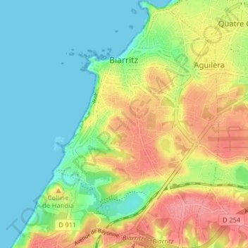
Name: Biarritz topographic map, elevation, terrain.
Average elevation: 112 ft
Minimum elevation: 0 ft
Maximum elevation: 285 ft
Make a donation
Gear up for your next adventure:
As an Amazon Associate, this site earns from qualifying purchases at no extra cost to you.
Other topographic maps
Click on a map to view its topography, its elevation and its terrain.
Château-Observatoire Abbadia
France > Nouvelle-Aquitaine > Pyrénées-Atlantiques > Hendaye > Sopite
Average elevation: 82 ft
Make a donation
Gear up for your next adventure:
As an Amazon Associate, this site earns from qualifying purchases at no extra cost to you.
Pic d'Orisson / Harburu
France > Nouvelle-Aquitaine > Pyrénées-Atlantiques > Saint-Michel
Average elevation: 2,680 ft
Make a donation
Gear up for your next adventure:
As an Amazon Associate, this site earns from qualifying purchases at no extra cost to you.
Izpegi
France > Nouvelle-Aquitaine > Pyrénées-Atlantiques > Saint-Étienne-de-Baïgorry
Average elevation: 2,073 ft
Pic d'Orisson / Harburu
France > Nouvelle-Aquitaine > Pyrénées-Atlantiques > Saint-Michel
Average elevation: 2,680 ft
Make a donation
Gear up for your next adventure:
As an Amazon Associate, this site earns from qualifying purchases at no extra cost to you.
Larroinea
France > Nouvelle-Aquitaine > Pyrénées-Atlantiques > Saint-Jean-Pied-de-Port
Average elevation: 669 ft
Larroinea
France > Nouvelle-Aquitaine > Pyrénées-Atlantiques > Saint-Jean-Pied-de-Port
Average elevation: 669 ft
Agerreko Larrea
France > Nouvelle-Aquitaine > Pyrénées-Atlantiques > Mouguerre
Average elevation: 128 ft
Make a donation
Gear up for your next adventure:
As an Amazon Associate, this site earns from qualifying purchases at no extra cost to you.