
Penting topographic map
Click on the map to display elevation.
Penting
Penting liegt auf 506 m ü. NHN circa fünf Kilometer südlich von Neunburg vorm Wald auf einem Höhenzug, der das Schwarzachtal vom Bodenwöhrer Becken trennt. Durch diese exponierte Lage ist der Ort besonders vom Schwarzachtal aus schon von weitem zu sehen.
About this map
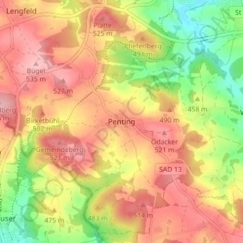
Name: Penting topographic map, elevation, terrain.
Average elevation: 1,542 ft
Minimum elevation: 1,257 ft
Maximum elevation: 1,759 ft
Other topographic maps
Click on a map to view its topography, its elevation and its terrain.
Pfahl
Deutschland > Bayern > Landkreis Schwandorf > Neunburg vorm Wald > Hofenstetten
Average elevation: 1,588 ft