
Make a donation
Gear up for your next adventure:
As an Amazon Associate, this site earns from qualifying purchases at no extra cost to you.
Zone 2 topographic map
Click on the map to display elevation.
Make a donation
Gear up for your next adventure:
As an Amazon Associate, this site earns from qualifying purchases at no extra cost to you.
Zone 2
La plus grande ville de la zone, Abala, est située en altitude environ 400 km au nord-ouest de Semera et une cinquantaine de kilomètres à l'est de Mekele.
Make a donation
Gear up for your next adventure:
As an Amazon Associate, this site earns from qualifying purchases at no extra cost to you.
About this map
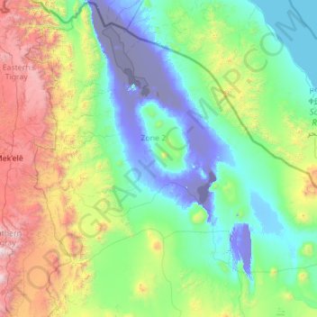
Name: Zone 2 topographic map, elevation, terrain.
Location: Zone 2, Afar, 1212, Éthiopie (12.70982 39.65086 14.54917 41.89998)
Average elevation: 2,136 ft
Minimum elevation: -417 ft
Maximum elevation: 12,900 ft
Make a donation
Gear up for your next adventure:
As an Amazon Associate, this site earns from qualifying purchases at no extra cost to you.
Other topographic maps
Click on a map to view its topography, its elevation and its terrain.
Make a donation
Gear up for your next adventure:
As an Amazon Associate, this site earns from qualifying purchases at no extra cost to you.