
Make a donation
Gear up for your next adventure:
As an Amazon Associate, this site earns from qualifying purchases at no extra cost to you.
Walpole topographic map
Click on the map to display elevation.
Make a donation
Gear up for your next adventure:
As an Amazon Associate, this site earns from qualifying purchases at no extra cost to you.
About this map
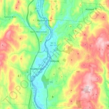
Name: Walpole topographic map, elevation, terrain.
Location: Walpole, Cheshire County, New Hampshire, United States (43.01492 -72.46802 43.16094 -72.35184)
Average elevation: 787 ft
Minimum elevation: 210 ft
Maximum elevation: 1,654 ft
Cheshire County trails, hiking, mountain biking, running and outdoor activities
Make a donation
Gear up for your next adventure:
As an Amazon Associate, this site earns from qualifying purchases at no extra cost to you.
Other topographic maps
Click on a map to view its topography, its elevation and its terrain.
Stone Pond
United States > New Hampshire > Cheshire County > Marlow > Gee Mill
Average elevation: 1,411 ft
Mount Monadnock
United States > New Hampshire > Cheshire County > Jaffrey
From the base to the summit, floral species diminish with increasingly shallow soil levels. The summit is home to many different specialized sub-alpine species which can retain moisture for long periods of time. Alpine and sub-alpine species include mountain ash, cotton grass, sheep laurel, mountain sandwort,…
Average elevation: 2,254 ft
Make a donation
Gear up for your next adventure:
As an Amazon Associate, this site earns from qualifying purchases at no extra cost to you.
Camp Notre Dame
United States > New Hampshire > Cheshire County > Chesterfield
Average elevation: 732 ft
Gilboa Mountain
United States > New Hampshire > Cheshire County > Westmoreland
Average elevation: 1,086 ft
Make a donation
Gear up for your next adventure:
As an Amazon Associate, this site earns from qualifying purchases at no extra cost to you.
Mount Monadnock
United States > New Hampshire > Cheshire County > Jaffrey
From the base to the summit, floral species diminish with increasingly shallow soil levels. The summit is home to many different specialized sub-alpine species which can retain moisture for long periods of time. Alpine and sub-alpine species include mountain ash, cotton grass, sheep laurel, mountain sandwort,…
Average elevation: 2,254 ft
West Chesterfield
United States > New Hampshire > Cheshire County > Chesterfield
Average elevation: 551 ft