Geolocate

Crodo topographic map

Click on the map to display elevation.

About this map

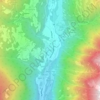
Name: Crodo topographic map, elevation, terrain.

Location: Crodo, Verbano-Cusio-Ossola, Piemonte, 28862, Italia (46.20330 8.30394 46.24330 8.34394)

Average elevation: 2,989 ft

Minimum elevation: 1,332 ft

Maximum elevation: 6,309 ft

Gear up for your next adventure:

🗃️Trail First Aid Kit - Essential kit for outdoor injuries and emergencies
🔥Plasma Lighters - Windproof lighters that work in any weather condition
📱Solar Portable Charger - Solar power bank for charging devices off‑grid
🥄Camping Utensil Set - Lightweight utensils for outdoor meals
📻Weather Alert Radios - Stay informed of storm risks while off-the-grid

As an Amazon Associate, this site earns from qualifying purchases at no extra cost to you.