
Make a donation
Gear up for your next adventure:
As an Amazon Associate, this site earns from qualifying purchases at no extra cost to you.
Mariaberg topographic map
Click on the map to display elevation.
Make a donation
Gear up for your next adventure:
As an Amazon Associate, this site earns from qualifying purchases at no extra cost to you.
Mariaberg
Mariaberg ist der nördlichste Ort im Landkreis Sigmaringen und grenzt im Norden unmittelbar an den Landkreis Reutlingen und im Westen an den Zollernalbkreis. Er befindet sich auf der Schwäbischen Alb im Regionalverband Bodensee-Oberschwaben. Der Ort liegt mit seiner hauptsächlichen Gebäudebebauung auf einer Anhöhe (bis ca. 780 m ü. NN ansteigend) über dem etwa 680 m ü. NN liegenden Tal der Lauchert an der Bundesstraße 313 auf halber Strecke zwischen den jeweils etwa 30 Kilometer entfernten Kreisstädten Sigmaringen (im Süden) und Reutlingen (im Norden).
Make a donation
Gear up for your next adventure:
As an Amazon Associate, this site earns from qualifying purchases at no extra cost to you.
About this map
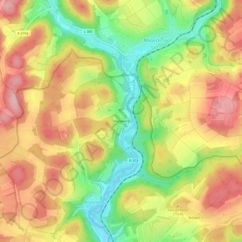
Name: Mariaberg topographic map, elevation, terrain.
Average elevation: 2,454 ft
Minimum elevation: 2,178 ft
Maximum elevation: 2,684 ft
Make a donation
Gear up for your next adventure:
As an Amazon Associate, this site earns from qualifying purchases at no extra cost to you.