
Paint Rock topographic map
Interactive map
Click on the map to display elevation.
About this map
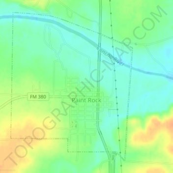
Name: Paint Rock topographic map, elevation, terrain.
Location: Paint Rock, Concho County, Texas, United States (31.49820 -99.93603 31.52138 -99.91373)
Average elevation: 1,637 ft
Minimum elevation: 1,588 ft
Maximum elevation: 1,699 ft
Other topographic maps
Click on a map to view its topography, its elevation and its terrain.
Eden
United States > Texas > Concho County
Eden, Concho County, Texas, 76837, United States
Average elevation: 2,051 ft
Eden
United States > Texas > Concho County > Eden
Eden, Concho County, Texas, 76839, United States
Average elevation: 2,060 ft
Lowake
United States > Texas > Concho County > Lowake
Lowake, Concho County, Texas, 76855, United States
Average elevation: 1,742 ft