
Make a donation
Gear up for your next adventure:
As an Amazon Associate, this site earns from qualifying purchases at no extra cost to you.
Spremberg topographic map
Click on the map to display elevation.
Make a donation
Gear up for your next adventure:
As an Amazon Associate, this site earns from qualifying purchases at no extra cost to you.
About this map
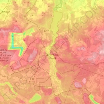
Name: Spremberg topographic map, elevation, terrain.
Average elevation: 377 ft
Minimum elevation: 95 ft
Maximum elevation: 548 ft
Make a donation
Gear up for your next adventure:
As an Amazon Associate, this site earns from qualifying purchases at no extra cost to you.
Other topographic maps
Click on a map to view its topography, its elevation and its terrain.
Groß Gastrose - Wjeliki Gósćeraz
Germany > Brandenburg > Spree-Neiße - Sprjewja-Nysa
Average elevation: 194 ft
Preilack - Pśiłuk
Germany > Brandenburg > Spree-Neiße - Sprjewja-Nysa > Turnow-Preilack
Average elevation: 217 ft
Kochsdorf - Kochanojce
Germany > Brandenburg > Spree-Neiße - Sprjewja-Nysa > Spremberg
Average elevation: 404 ft