Geolocate

Bandera topographic map

Click on the map to display elevation.

About this map

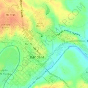
Name: Bandera topographic map, elevation, terrain.

Location: Bandera, Bandera County, Texas, United States (29.72839 -99.07181 29.73349 -99.06762)

Average elevation: 1,257 ft

Minimum elevation: 1,194 ft

Maximum elevation: 1,322 ft

Texas trails, hiking, mountain biking, running and outdoor activities

Gear up for your next adventure:

📶Vehicle Signal Boosters - Improve reception in rural areas while driving to trailheads
🦶Hiking Gaiters - Keep debris and water out of your boots
🪶Camp Gear Gift Set - Perfect gift bundle for outdoor fans
🪶Thermal Camp Blanket - Extra warmth for cold nights
🚗GPS Dash Cams - Record your scenic drives through mountain passes and canyons

As an Amazon Associate, this site earns from qualifying purchases at no extra cost to you.