
Make a donation
Gear up for your next adventure:
As an Amazon Associate, this site earns from qualifying purchases at no extra cost to you.
Amlach topographic map
Click on the map to display elevation.
Make a donation
Gear up for your next adventure:
As an Amazon Associate, this site earns from qualifying purchases at no extra cost to you.
About this map
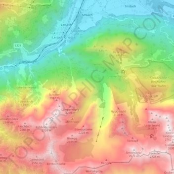
Name: Amlach topographic map, elevation, terrain.
Location: Amlach, Bezirk Lienz, Tyrol, 9908, Autriche (46.74729 12.73474 46.81966 12.79582)
Average elevation: 5,266 ft
Minimum elevation: 2,146 ft
Maximum elevation: 8,970 ft
Make a donation
Gear up for your next adventure:
As an Amazon Associate, this site earns from qualifying purchases at no extra cost to you.
Other topographic maps
Click on a map to view its topography, its elevation and its terrain.
Barmer Spitze
Autriche > Tyrol > Bezirk Lienz > Sankt Jakob in Defereggen
La Barmer Spitze est une montagne qui s’élève à 3 200 m d’altitude dans les Hohe Tauern, à la frontière entre l'Autriche et l'Italie.
Average elevation: 9,245 ft
Make a donation
Gear up for your next adventure:
As an Amazon Associate, this site earns from qualifying purchases at no extra cost to you.