
Make a donation
Gear up for your next adventure:
As an Amazon Associate, this site earns from qualifying purchases at no extra cost to you.
Lauenstein topographic map
Click on the map to display elevation.
Make a donation
Gear up for your next adventure:
As an Amazon Associate, this site earns from qualifying purchases at no extra cost to you.
Lauenstein
Lauenstein liegt etwa 40 km südlich von Dresden im Osterzgebirge im oberen Tal der Müglitz. Der Ort erstreckt sich vom Bahnhof auf 470 m Höhe an den linken Hängen der Müglitz bis 710 m hoch aufsteigend über dem Fluss. Das Zentrum befindet sich auf einer Terrasse etwa 50 m über dem Müglitztal.
Make a donation
Gear up for your next adventure:
As an Amazon Associate, this site earns from qualifying purchases at no extra cost to you.
About this map
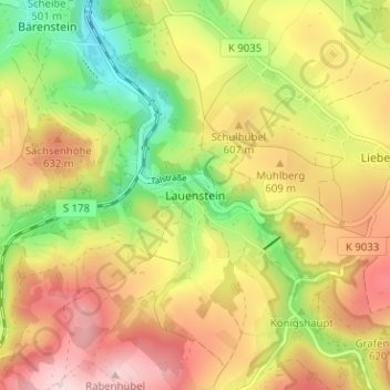
Name: Lauenstein topographic map, elevation, terrain.
Average elevation: 1,886 ft
Minimum elevation: 1,434 ft
Maximum elevation: 2,316 ft
Make a donation
Gear up for your next adventure:
As an Amazon Associate, this site earns from qualifying purchases at no extra cost to you.