
Thank you for supporting this site ❤️
Make a donation
Make a donation
Gear up for your next adventure:
As an Amazon Associate, this site earns from qualifying purchases at no extra cost to you.
Karaj topographic map
Click on the map to display elevation.
Thank you for supporting this site ❤️
Make a donation
Make a donation
Gear up for your next adventure:
As an Amazon Associate, this site earns from qualifying purchases at no extra cost to you.
About this map
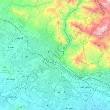
Name: Karaj topographic map, elevation, terrain.
Location: Karaj, Karaj Central District, Karaj County, 3144614491, Iran (35.66249 50.83047 35.98249 51.15047)
Average elevation: 5,164 ft
Minimum elevation: 3,678 ft
Maximum elevation: 11,040 ft
Thank you for supporting this site ❤️
Make a donation
Make a donation
Gear up for your next adventure:
As an Amazon Associate, this site earns from qualifying purchases at no extra cost to you.