
Make a donation
Gear up for your next adventure:
As an Amazon Associate, this site earns from qualifying purchases at no extra cost to you.
Burgstein topographic map
Click on the map to display elevation.
Make a donation
Gear up for your next adventure:
As an Amazon Associate, this site earns from qualifying purchases at no extra cost to you.
Burgstein
Der waldfreie Gipfelbereich besteht aus einer großen Granit-Steinplatte, umgeben von Fichtenwald. 200 m östlich befindet sich der Burgsteinfelsen mit einer Höhe von 869 m (Lage49.99972222222211.994166666667869), eine mächtige Granitfelsburg und geschütztes Naturdenkmal.
Make a donation
Gear up for your next adventure:
As an Amazon Associate, this site earns from qualifying purchases at no extra cost to you.
About this map
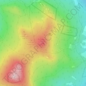
Name: Burgstein topographic map, elevation, terrain.
Average elevation: 2,428 ft
Minimum elevation: 1,975 ft
Maximum elevation: 3,005 ft
Make a donation
Gear up for your next adventure:
As an Amazon Associate, this site earns from qualifying purchases at no extra cost to you.
Other topographic maps
Click on a map to view its topography, its elevation and its terrain.
Kapple
Deutschland > Bayern > Landkreis Wunsiedel im Fichtelgebirge > Wunsiedel > Schönbrunn > Göringsreuth
Average elevation: 1,926 ft