
Make a donation
Gear up for your next adventure:
As an Amazon Associate, this site earns from qualifying purchases at no extra cost to you.
Habergy topographic map
Click on the map to display elevation.
Make a donation
Gear up for your next adventure:
As an Amazon Associate, this site earns from qualifying purchases at no extra cost to you.
Habergy
Le village fait partie du bassin hydrographique de la Meuse. Il est traversé par deux ruisseaux, la Kringelt et la Brebingerbach. Ceux-ci rejoignent l'Udingerbach près de Buvange. Leurs eaux se jettent dans la Messancy et enfin dans la Chiers. L'altitude des plateaux oscille entre 360 et 400 mètres avec un point culminant à 402 mètres.
Make a donation
Gear up for your next adventure:
As an Amazon Associate, this site earns from qualifying purchases at no extra cost to you.
About this map
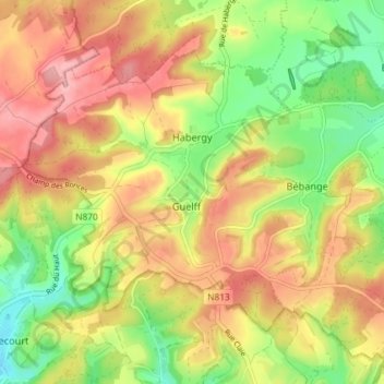
Name: Habergy topographic map, elevation, terrain.
Location: Habergy, Messancy, Arlon, Luxembourg, Wallonie, 6782, Belgique (49.59139 5.72862 49.62582 5.80129)
Average elevation: 1,102 ft
Minimum elevation: 866 ft
Maximum elevation: 1,322 ft
Make a donation
Gear up for your next adventure:
As an Amazon Associate, this site earns from qualifying purchases at no extra cost to you.