
Thank you for supporting this site ❤️
Make a donation
Make a donation
Gear up for your next adventure:
As an Amazon Associate, this site earns from qualifying purchases at no extra cost to you.
Cayenne topographic map
Click on the map to display elevation.
Thank you for supporting this site ❤️
Make a donation
Make a donation
Gear up for your next adventure:
As an Amazon Associate, this site earns from qualifying purchases at no extra cost to you.
About this map
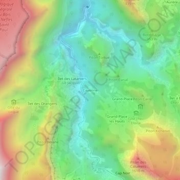
Name: Cayenne topographic map, elevation, terrain.
Location: Cayenne, La Possession, Saint-Paul, Réunion, 97419, France (-21.05951 55.38450 -21.01951 55.42450)
Average elevation: 3,005 ft
Minimum elevation: 1,043 ft
Maximum elevation: 6,260 ft
Thank you for supporting this site ❤️
Make a donation
Make a donation
Gear up for your next adventure:
As an Amazon Associate, this site earns from qualifying purchases at no extra cost to you.