
Make a donation
Gear up for your next adventure:
As an Amazon Associate, this site earns from qualifying purchases at no extra cost to you.
Guaqui topographic map
Click on the map to display elevation.
Make a donation
Gear up for your next adventure:
As an Amazon Associate, this site earns from qualifying purchases at no extra cost to you.
Guaqui
Guaqui es una localidad y municipio boliviano en la provincia de Ingavi dentro del departamento de La Paz. Se encuentra ubicado a orillas del lago Titicaca a 92 km de la ciudad de La Paz. Está a una altitud de 3811 m s. n. m. con una temperatura de 18 °C promedio y tiene una superficie de 183 km².
Make a donation
Gear up for your next adventure:
As an Amazon Associate, this site earns from qualifying purchases at no extra cost to you.
About this map
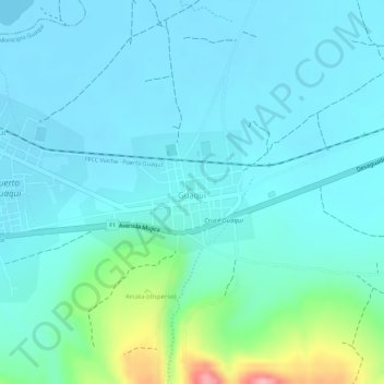
Name: Guaqui topographic map, elevation, terrain.
Location: Guaqui, Municipio Guaqui, Ingavi, La Paz, Bolivia (-16.60156 -68.84515 -16.59283 -68.83223)
Average elevation: 12,605 ft
Minimum elevation: 12,520 ft
Maximum elevation: 12,989 ft
Make a donation
Gear up for your next adventure:
As an Amazon Associate, this site earns from qualifying purchases at no extra cost to you.