
Hessisch Lichtenau topographic map
Interactive map
Click on the map to display elevation.
About this map
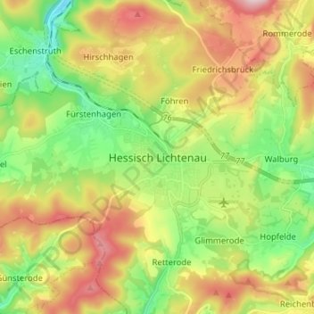
Name: Hessisch Lichtenau topographic map, elevation, terrain.
Location: Hessisch Lichtenau, Werra-Meißner-Kreis, Hesse, 37235, Germany (51.16000 9.67667 51.24000 9.75667)
Average elevation: 1,378 ft
Minimum elevation: 925 ft
Maximum elevation: 1,995 ft
Other topographic maps
Click on a map to view its topography, its elevation and its terrain.
Neuerode
Germany > Hesse > Werra-Meißner-Kreis
Neuerode, Meinhard, Werra-Meißner-Kreis, Hesse, Germany
Average elevation: 1,171 ft
Konstein
Germany > Hesse > Werra-Meißner-Kreis > Wanfried
Konstein, Wanfried, Werra-Meißner-Kreis, Hesse, Germany
Average elevation: 1,201 ft
Wanfried
Germany > Hesse > Werra-Meißner-Kreis > Wanfried
Wanfried, Werra-Meißner-Kreis, Hesse, Germany
Average elevation: 928 ft
Frankershausen
Germany > Hesse > Werra-Meißner-Kreis > Berkatal > Frankershausen
Frankershausen, Berkatal, Werra-Meißner-Kreis, Hesse, 37297, Germany
Average elevation: 955 ft
Berkatal
Germany > Hesse > Werra-Meißner-Kreis
Berkatal, Werra-Meißner-Kreis, Hesse, 37297, Germany
Average elevation: 1,093 ft
Bad Sooden-Allendorf
Germany > Hesse > Werra-Meißner-Kreis
Bad Sooden-Allendorf, Werra-Meißner-Kreis, Hesse, 37242, Germany
Average elevation: 988 ft
Hessisch Lichtenau
Germany > Hesse > Werra-Meißner-Kreis
Hessisch Lichtenau, Werra-Meißner-Kreis, Hesse, 37235, Germany
Average elevation: 1,365 ft