
Thank you for supporting this site ❤️
Make a donation
Make a donation
Gear up for your next adventure:
As an Amazon Associate, this site earns from qualifying purchases at no extra cost to you.
Muleshoe topographic map
Click on the map to display elevation.
Thank you for supporting this site ❤️
Make a donation
Make a donation
Gear up for your next adventure:
As an Amazon Associate, this site earns from qualifying purchases at no extra cost to you.
About this map
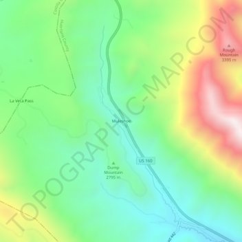
Name: Muleshoe topographic map, elevation, terrain.
Location: Muleshoe, Huerfano County, Colorado, United States (37.56973 -105.20250 37.60973 -105.16250)
Average elevation: 9,455 ft
Minimum elevation: 8,376 ft
Maximum elevation: 11,447 ft
Huerfano County trails, hiking, mountain biking, running and outdoor activities
Thank you for supporting this site ❤️
Make a donation
Make a donation
Gear up for your next adventure:
As an Amazon Associate, this site earns from qualifying purchases at no extra cost to you.