
Vlasina topographic map
Interactive map
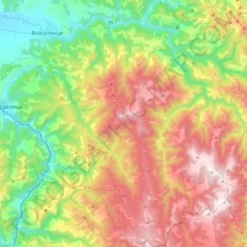
Click on the map to display elevation.
About this map
Name: Vlasina topographic map, elevation, terrain.
Average elevation: 2,789 ft
Minimum elevation: 784 ft
Maximum elevation: 5,640 ft
The Vlasina flows out from the Vlasina Lake at an altitude of 1,213 m. Lake used to be a large, muddy peat bog, but in 1947-1951 the Vlasina was dammed by the long, earth dam and the bog was turned into an artificial lake. The river flows to the north, between the mountains of Čemernik on the west, and Gramada on the east. It flows through Crna Trava, regional and municipal center, and the villages of Brod, Krstićevo and Jabukovik, where it reaches the Lužnica mountain and receives the Gradska from the right.
Other topographic maps
Click on a map to view its topography, its elevation and its terrain.
Obradovce
Serbia > Central Serbia > Jablanica Administrative District > Crna Trava Municipality
Obradovce, Crna Trava Municipality, Jablanica Administrative District, Central Serbia, 16215, Serbia
Average elevation: 3,878 ft
Скобаљић Град
Serbia > Central Serbia > Jablanica Administrative District > City of Leskovac
Скобаљић Град, 436, Vucje, City of Leskovac, Jablanica Administrative District, Central Serbia, 16203, Serbia
Average elevation: 1,732 ft
City of Leskovac
Serbia > Central Serbia > Jablanica Administrative District > City of Leskovac
City of Leskovac, Jablanica Administrative District, Central Serbia, Serbia
Average elevation: 1,844 ft