
Make a donation
Gear up for your next adventure:
As an Amazon Associate, this site earns from qualifying purchases at no extra cost to you.
Sankt Wendel topographic map
Click on the map to display elevation.
Make a donation
Gear up for your next adventure:
As an Amazon Associate, this site earns from qualifying purchases at no extra cost to you.
Sankt Wendel
St. Wendel is situated on the river Blies west of the Bosenberg hill at an elevation of 938 feet (286 m). Its highest elevation is the Bosenberg hill at 1591 feet (485 m); the lowest is where the river Blies exits St. Wendel heading for Ottweiler at 853 feet (260 m).
Make a donation
Gear up for your next adventure:
As an Amazon Associate, this site earns from qualifying purchases at no extra cost to you.
About this map
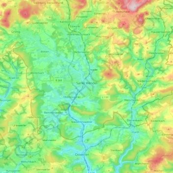
Name: Sankt Wendel topographic map, elevation, terrain.
Location: Sankt Wendel, Landkreis St. Wendel, Saarland, 66606, Germany (49.41609 7.06774 49.51141 7.30564)
Average elevation: 1,178 ft
Minimum elevation: 827 ft
Maximum elevation: 1,932 ft
Make a donation
Gear up for your next adventure:
As an Amazon Associate, this site earns from qualifying purchases at no extra cost to you.
Other topographic maps
Click on a map to view its topography, its elevation and its terrain.