Geolocate

Challuabamba topographic map

Click on the map to display elevation.

About this map

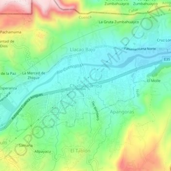
Name: Challuabamba topographic map, elevation, terrain.

Location: Challuabamba, Cuenca, Azuay, 010158, Ecuador (-2.87327 -78.93032 -2.83327 -78.89032)

Average elevation: 8,104 ft

Minimum elevation: 7,648 ft

Maximum elevation: 9,062 ft

Other topographic maps

Click on a map to view its topography, its elevation and its terrain.

Río Tomebamba

Ecuador > Azuay > Cuenca

Average elevation: 8,212 ft

San Sebastián

Ecuador > Azuay > Cuenca

Average elevation: 9,026 ft

Gear up for your next adventure:

🛶Inflatable Kayak - Portable kayak for rivers, lakes, and expeditions
🌡️Portable Weather Meter - Track weather conditions on the trail
Solar GPS Watches - Advanced multisport watches with built-in topographic maps
🥾Women's Hiking Boots - Top-rated trail boots with ankle support and superior grip
🛌Ultralight Sleeping Bags - Compact down bags for cold nights in the wilderness

As an Amazon Associate, this site earns from qualifying purchases at no extra cost to you.