
Make a donation
Gear up for your next adventure:
As an Amazon Associate, this site earns from qualifying purchases at no extra cost to you.
Rio Beberibe topographic map
Click on the map to display elevation.
Make a donation
Gear up for your next adventure:
As an Amazon Associate, this site earns from qualifying purchases at no extra cost to you.
About this map
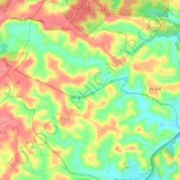
Name: Rio Beberibe topographic map, elevation, terrain.
Average elevation: 217 ft
Minimum elevation: 72 ft
Maximum elevation: 351 ft
Make a donation
Gear up for your next adventure:
As an Amazon Associate, this site earns from qualifying purchases at no extra cost to you.
Other topographic maps
Click on a map to view its topography, its elevation and its terrain.
Make a donation
Gear up for your next adventure:
As an Amazon Associate, this site earns from qualifying purchases at no extra cost to you.
Recife
Brasil > Pernambuco > Recife
A altitude média em relação ao nível do mar é de quatro metros. Sua área territorial é composta de 67,43% de morros, 23,26% de planícies, 9,31% de áreas alagadas (aquáticas) e 5,58% de zonas especiais de preservação ambiental (ZEPA).
Average elevation: 75 ft
Make a donation
Gear up for your next adventure:
As an Amazon Associate, this site earns from qualifying purchases at no extra cost to you.