
Lakeport topographic map
Interactive map
Click on the map to display elevation.
About this map
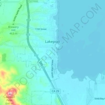
Name: Lakeport topographic map, elevation, terrain.
Location: Lakeport, Lake County, California, United States (39.01178 -122.93823 39.06328 -122.91098)
Average elevation: 1,401 ft
Minimum elevation: 1,312 ft
Maximum elevation: 2,152 ft
Lakeport is an incorporated city and the county seat of Lake County, California. This city is 125 miles (201 km) northwest of Sacramento. Lakeport is on the western shore of the county namesake, Clear Lake, at an elevation of 1,355 feet (413 m). The population was 5,026 at the 2020 census, up from 4,753 at the 2010 census.
Other topographic maps
Click on a map to view its topography, its elevation and its terrain.
Clearlake Oaks
United States > California > Lake County
Clearlake Oaks, Lake County, California, 95423, United States
Average elevation: 1,709 ft
Soda Bay
United States > California > Lake County
Soda Bay, Lake County, California, 95451, United States
Average elevation: 1,857 ft
North Lakeport
United States > California > Lake County
North Lakeport, Lake County, California, United States
Average elevation: 1,401 ft
Nice
United States > California > Lake County
Nice, Lake County, California, United States
Average elevation: 1,841 ft
Lucerne
United States > California > Lake County
Lucerne, Lake County, California, 95458, United States
Average elevation: 1,703 ft
Lakeport
United States > California > Lake County
Lakeport, Lake County, California, United States
Average elevation: 1,368 ft
Mount Konocti
United States > California > Lake County
Mount Konocti, Lake County, California, 95451, United States
Average elevation: 3,104 ft
Upper Lake
United States > California > Lake County
Upper Lake, Lake County, California, 95485, United States
Average elevation: 1,407 ft
Honeymoon Cove
United States > California > Lake County
Honeymoon Cove, Lake County, California, 95443, United States
Average elevation: 1,339 ft
Spring Valley
United States > California > Lake County
Spring Valley, Lake County, California, United States
Average elevation: 1,601 ft
Lower Lake
United States > California > Lake County
Lower Lake, Lake County, California, 95457, United States
Average elevation: 1,608 ft
Middletown
United States > California > Lake County > Middletown
Middletown, Lake County, California, United States
Average elevation: 1,237 ft
Hobergs
United States > California > Lake County > Cobb
Hobergs, Cobb, Lake County, California, 95426, United States
Average elevation: 2,867 ft
Hidden Valley Lake
United States > California > Lake County
Hidden Valley Lake, Lake County, California, 95467, United States
Average elevation: 1,276 ft
Cobb
United States > California > Lake County
Cobb, Lake County, California, 95426, United States
Average elevation: 2,910 ft
Clear Lake
United States > California > Lake County > Lakeport
Clear Lake, Lakeport, Lake County, California, 95443, United States
Average elevation: 1,742 ft
Clearlake
United States > California > Lake County
Clearlake, Lake County, California, United States
Average elevation: 1,555 ft
Kelseyville
United States > California > Lake County
Kelseyville, Lake County, California, 95451, United States
Average elevation: 1,414 ft