
Upper Lake topographic map
Click on the map to display elevation.
Upper Lake
Upper Lake is a census-designated place (CDP) in Lake County, California, United States. Upper Lake is located 8 miles (13 km) north of Lakeport, at an elevation of 1,345 feet (410 m). The population was 1,052 at the 2010 census, up from 989 at the 2000 census. The Habematolel Pomo of Upper Lake are headquartered here.
About this map
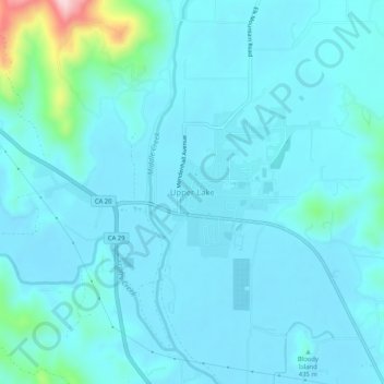
Name: Upper Lake topographic map, elevation, terrain.
Location: Upper Lake, Lake County, California, 95485, United States (39.14461 -122.93055 39.18461 -122.89055)
Average elevation: 1,407 ft
Minimum elevation: 1,312 ft
Maximum elevation: 2,175 ft
Lake County trails, hiking, mountain biking, running and outdoor activities
Other topographic maps
Click on a map to view its topography, its elevation and its terrain.
Lakeport
United States > California > Lake County
Lakeport is an incorporated city and the county seat of Lake County, California. This city is 125 miles (201 km) northwest of Sacramento. Lakeport is on the western shore of the county namesake, Clear Lake, at an elevation of 1,355 feet (413 m). The population was 5,026 at the 2020 census, up from 4,753 at the…
Average elevation: 1,368 ft
Nice
United States > California > Lake County
Nice is a census-designated place (CDP) in Lake County, California, United States. Nice is located 4.5 miles (7.2 km) southeast of Upper Lake, at an elevation of 1362 feet (415 m). The population was 2,731 at the 2010 census, up from 2,509 at the 2000 census.
Average elevation: 1,841 ft
Clear Lake
United States > California > Lake County > Lakeport
Clear Lake is 19 mi (31 km) by 8 mi (13 km) at its widest point, with a surface area of 43,785 acres (17,719 ha) and a 1,155,000 acre⋅ft (1,425,000 dam3) capacity. Average depth is 27 ft (8.2 m), maximum is 60 ft (18 m), lake elevation is 1,329 ft (405 m), and average water temperature is 40 °F (4 °C) in…
Average elevation: 1,742 ft
Middletown
United States > California > Lake County > Middletown
Middletown has an elevation of 1,099 feet (335 m). According to the United States Census Bureau, the CDP has a total area of 1.8 square miles (4.7 km2), all of it land.
Average elevation: 1,237 ft
Lower Lake
United States > California > Lake County
Lower Lake is located 4.5 miles (7.2 km) southwest of the City of Clearlake, and 13 miles (21 km) southeast of Kelseyville. It is at an elevation of 1,371 feet (418 m). Lower Lake was at one point the county seat; the Lake County elections of 1867 were hotly contested, with the seat moving between what is now…
Average elevation: 1,608 ft
Clearlake Oaks
United States > California > Lake County
Clearlake Oaks is a census-designated place (CDP) in Lake County, California, United States. It is located on the northeast of Clear Lake, 8 miles (13.8 km) northwest of the town of Clearlake, at an elevation of 1,335 feet (407 m). The population was 2,359 at the 2010 census, down from 2,402 at the 2000 census.
Average elevation: 1,709 ft