
Lower Lake topographic map
Click on the map to display elevation.
Lower Lake
Lower Lake is located 4.5 miles (7.2 km) southwest of the City of Clearlake, and 13 miles (21 km) southeast of Kelseyville. It is at an elevation of 1,371 feet (418 m). Lower Lake was at one point the county seat; the Lake County elections of 1867 were hotly contested, with the seat moving between what is now the city of Lakeport and the town of Lower Lake. In 1870, the feud was settled and Lakeport controlled the seat. Although some believe the seat was stolen from Lower Lake, it has remained in Lakeport for over a century and is no longer a topic of concern for locals. At the 2000 census, according to the United States Census Bureau, the CDP had a total area of 7.9 square miles (20 km2), of which 7.9 square miles (20 km2) was land and 0.1 square miles (0.26 km2) (0.88%) was water.
About this map
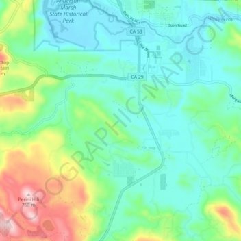
Name: Lower Lake topographic map, elevation, terrain.
Location: Lower Lake, Lake County, California, 95457, United States (38.86316 -122.65070 38.93195 -122.58551)
Average elevation: 1,608 ft
Minimum elevation: 1,302 ft
Maximum elevation: 2,490 ft
Lake County trails, hiking, mountain biking, running and outdoor activities
Other topographic maps
Click on a map to view its topography, its elevation and its terrain.
Clear Lake
United States > California > Lake County > Lakeport
Clear Lake is 19 mi (31 km) by 8 mi (13 km) at its widest point, with a surface area of 43,785 acres (17,719 ha) and a 1,155,000 acre⋅ft (1,425,000 dam3) capacity. Average depth is 27 ft (8.2 m), maximum is 60 ft (18 m), lake elevation is 1,329 ft (405 m), and average water temperature is 40 °F (4 °C) in…
Average elevation: 1,742 ft
Cobb
United States > California > Lake County
Cobb is a census designated place (CDP) in Lake County, California, United States. Cobb is located 1 mile (1.6 km) northwest of Whispering Pines, at an elevation of 2,631 feet (802 m). The population was 1,778 at the 2010 census, up from 1,638 at the 2000 census.
Average elevation: 2,910 ft
Upper Lake
United States > California > Lake County
Upper Lake is a census-designated place (CDP) in Lake County, California, United States. Upper Lake is located 8 miles (13 km) north of Lakeport, at an elevation of 1,345 feet (410 m). The population was 1,052 at the 2010 census, up from 989 at the 2000 census. The Habematolel Pomo of Upper Lake are…
Average elevation: 1,407 ft