
Westland topographic map
Interactive map
Click on the map to display elevation.
About this map
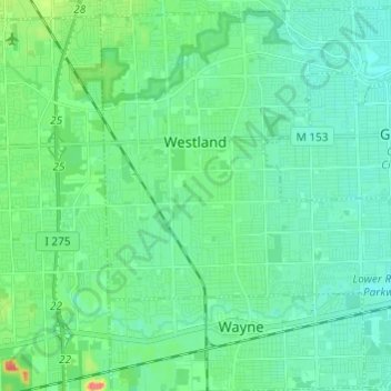
Name: Westland topographic map, elevation, terrain.
Location: Westland, Wayne County, Michigan, United States (42.26746 -83.43004 42.35518 -83.30900)
Average elevation: 663 ft
Minimum elevation: 623 ft
Maximum elevation: 810 ft
Wayne County trails, hiking, mountain biking, running and outdoor activities
Other topographic maps
Click on a map to view its topography, its elevation and its terrain.
Kresge Ford Basement Courtyard
United States > Michigan > Wayne County > Detroit
Average elevation: 633 ft
Greenfield Village
United States > Michigan > Wayne County > Greenfield Village
Average elevation: 604 ft