
Wellington Island topographic map
Interactive map
Click on the map to display elevation.
About this map
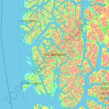
Name: Wellington Island topographic map, elevation, terrain.
Average elevation: 689 ft
Minimum elevation: -10 ft
Maximum elevation: 4,636 ft
Other topographic maps
Click on a map to view its topography, its elevation and its terrain.
Puerto Natales
Chile > Magallanes and Chilean Antarctica Region > Provincia de Última Esperanza
Average elevation: 463 ft
Puerto Natales
Chile > Magallanes and Chilean Antarctica Region > Provincia de Última Esperanza
Average elevation: 463 ft
Isla Cabrera
Chile > Magallanes and Chilean Antarctica Region > Provincia de Última Esperanza
Average elevation: 262 ft
Laguna de los Cisnes
Chile > Magallanes and Chilean Antarctica Region > Provincia de Tierra del Fuego > Porvenir
Average elevation: 102 ft
Cerro Torre
Chile > Magallanes and Chilean Antarctica Region > Provincia de Última Esperanza > Puerto Natales
Average elevation: 6,286 ft
Cerro Torre
Chile > Magallanes and Chilean Antarctica Region > Provincia de Última Esperanza
Average elevation: 6,286 ft
Puerto Williams
Chile > Magallanes and Chilean Antarctica Region > Provincia de la Antártica Chilena > Cape Horn
The climate of Puerto Williams is a temperate subpolar oceanic climate (Cfc) bordering closely on a tundra climate (ET) according to the Köppen climate classification. The summers are short and cool while the winters are long, wet, but moderate. Rainfall is around 512.3 mm (20 in) a year and temperatures are…
Average elevation: 495 ft
Cabo Conventry
Chile > Magallanes and Chilean Antarctica Region > Provincia de Magallanes > Punta Arenas
Average elevation: 62 ft