
Wellington Island topographic map
Interactive map
Click on the map to display elevation.
About this map
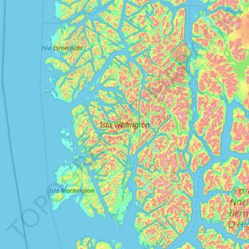
Name: Wellington Island topographic map, elevation, terrain.
Average elevation: 689 ft
Minimum elevation: -10 ft
Maximum elevation: 4,636 ft
Other topographic maps
Click on a map to view its topography, its elevation and its terrain.
Cerro Ballena
Chile > Region of Magallanes and Chilean Antarctica > Provincia de Última Esperanza > Puerto Natales
Average elevation: 1,312 ft
Serrano Glacier
Chile > Region of Magallanes and Chilean Antarctica > Provincia de Última Esperanza > Torres del Paine
Average elevation: 948 ft
Cape Horn
Chile > Region of Magallanes and Chilean Antarctica > Provincia de la Antártica Chilena > Cape Horn
Average elevation: 131 ft
Aeropuerto
Chile > Region of Magallanes and Chilean Antarctica > Provincia de Magallanes > Punta Arenas
Average elevation: 69 ft
Zona Austral
Chile > Region of Magallanes and Chilean Antarctica > Provincia de Última Esperanza > Puerto Natales
In the far south (Chile Austral), which extends from Valdivia through the Chacao Channel to Cape Horn, the Andes and the South Pacific meet. This district of the country is mountainous, heavily forested and inhospitable. The deeply indented coastline is filled with islands which preserve the general outline of…
Average elevation: 2,520 ft
Lake Pehoé
Chile > Region of Magallanes and Chilean Antarctica > Provincia de Última Esperanza > Torres del Paine
Average elevation: 226 ft
Peak
Chile > Region of Magallanes and Chilean Antarctica > Provincia de Magallanes > Punta Arenas
Average elevation: 157 ft
Co. Santiago Benadava
Chile > Region of Magallanes and Chilean Antarctica > Provincia de la Antártica Chilena > Cape Horn
Average elevation: 3,045 ft
Monte Fitz Roy
Chile > Region of Magallanes and Chilean Antarctica > Provincia de Última Esperanza > Puerto Natales
Average elevation: 6,637 ft
Chair
Chile > Region of Magallanes and Chilean Antarctica > Provincia de la Antártica Chilena > Cape Horn
Average elevation: 59 ft