
Huete topographic map
Interactive map
Click on the map to display elevation.
About this map
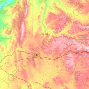
Name: Huete topographic map, elevation, terrain.
Location: Huete, Cuenca, Castile-La Mancha, Spain (39.88107 -2.76745 40.30404 -2.45927)
Average elevation: 2,913 ft
Minimum elevation: 1,909 ft
Maximum elevation: 3,842 ft
Other topographic maps
Click on a map to view its topography, its elevation and its terrain.
Arenas
Spain > Castile-La Mancha > La Mancha > Alcázar de San Juan > Alameda de Cervera
Average elevation: 2,103 ft
Alto Llano
Spain > Castile-La Mancha > Mancha Alta de Toledo > Quintanar de la Orden
Average elevation: 2,290 ft