
Brentwood topographic map
Interactive map
Click on the map to display elevation.
About this map
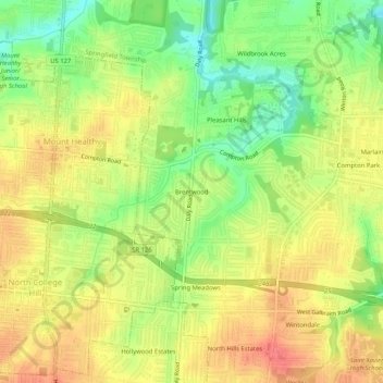
Name: Brentwood topographic map, elevation, terrain.
Average elevation: 814 ft
Minimum elevation: 702 ft
Maximum elevation: 902 ft
Hamilton County trails, hiking, mountain biking, running and outdoor activities
Other topographic maps
Click on a map to view its topography, its elevation and its terrain.
Loveland
United States > Ohio > Hamilton County
According to the United States Census Bureau, the city has a total area of 5.00 square miles (12.95 km2), of which 4.93 square miles (12.77 km2) is land and 0.07 square miles (0.18 km2) is water. The city is situated at an elevation of 597 ft (182 m) above sea level.
Average elevation: 728 ft
Mount Healthy Heights
United States > Ohio > Hamilton County > Mount Healthy Heights
Average elevation: 860 ft
Clifton Heights–University Heights–Fairview
United States > Ohio > Hamilton County > Cincinnati
Average elevation: 656 ft
Camp John McLean Memorial Park
United States > Ohio > Hamilton County > Wyoming > Park Place
Average elevation: 679 ft