
Lakeside Park topographic map
Interactive map
Click on the map to display elevation.
About this map
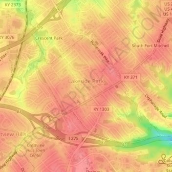
Name: Lakeside Park topographic map, elevation, terrain.
Location: Lakeside Park, Kenton County, Kentucky, 41017, United States (39.02600 -84.57911 39.04356 -84.55411)
Average elevation: 837 ft
Minimum elevation: 653 ft
Maximum elevation: 896 ft
Kenton County trails, hiking, mountain biking, running and outdoor activities
Other topographic maps
Click on a map to view its topography, its elevation and its terrain.
Austinburg
United States > Kentucky > Kenton County > Covington > Austinburg
Average elevation: 584 ft
Daniel Carter Beard Boyhood Home
United States > Kentucky > Kenton County > Covington
Average elevation: 515 ft