Geolocate

Piner topographic map

Click on the map to display elevation.

About this map

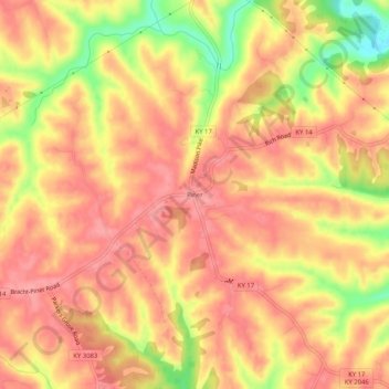
Name: Piner topographic map, elevation, terrain.

Location: Piner, Kenton County, Kentucky, 41163, United States (38.81145 -84.55577 38.85145 -84.51577)

Average elevation: 823 ft

Minimum elevation: 617 ft

Maximum elevation: 915 ft

Kenton County trails, hiking, mountain biking, running and outdoor activities

Other topographic maps

Click on a map to view its topography, its elevation and its terrain.

Pride Park

United States > Kentucky > Kenton County > Taylor Mill

Average elevation: 778 ft

Fort Wright

United States > Kentucky > Kenton County

Average elevation: 719 ft

Taylor Mill

United States > Kentucky > Kenton County

Average elevation: 692 ft

Gear up for your next adventure:

💧Water Purification System - Clean water on the trail with reliable purifiers
🎒Trail Energy Bars - High‑calorie bars for hiking energy
🕶️GPS Smartphone Mount - Secure mount for phone navigation
📦Gear Storage Bags - Organize and protect outdoor equipment
🧤Hiking Gloves - Protective gloves for rugged trails

As an Amazon Associate, this site earns from qualifying purchases at no extra cost to you.