
Tagus topographic map
Interactive map
Click on the map to display elevation.
About this map
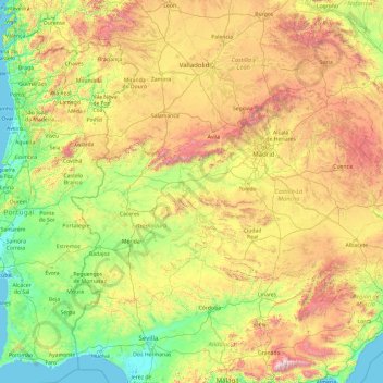
Name: Tagus topographic map, elevation, terrain.
Location: Tagus, Toledo, Castile-La Mancha, 28300, Spain (38.67039 -9.28791 40.80513 -1.69810)
Average elevation: 2,041 ft
Minimum elevation: -3 ft
Maximum elevation: 11,089 ft
Other topographic maps
Click on a map to view its topography, its elevation and its terrain.
Arenas
Spain > Castile-La Mancha > La Mancha > Alcázar de San Juan > Alameda de Cervera
Average elevation: 2,103 ft
Alto Llano
Spain > Castile-La Mancha > Mancha Alta de Toledo > Quintanar de la Orden
Average elevation: 2,290 ft