
Landsberg am Lech topographic map
Interactive map
Click on the map to display elevation.
About this map
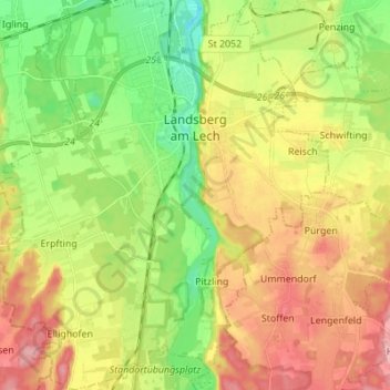
Name: Landsberg am Lech topographic map, elevation, terrain.
Average elevation: 2,054 ft
Minimum elevation: 1,860 ft
Maximum elevation: 2,274 ft
Other topographic maps
Click on a map to view its topography, its elevation and its terrain.
Ammersee
Germany > Bavaria > Landkreis Landsberg am Lech > Schondorf am Ammersee
Ammersee, Schondorf am Ammersee, Schondorf a.Ammersee (VGem), Landkreis Landsberg am Lech, Bavaria, Germany
Average elevation: 1,955 ft
Ammersee
Germany > Bavaria > Landkreis Landsberg am Lech
Ammersee, Landkreis Landsberg am Lech, Bavaria, Germany
Average elevation: 1,955 ft