
Willaston topographic map
Interactive map
Click on the map to display elevation.
About this map
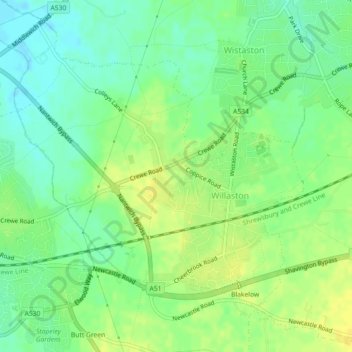
Name: Willaston topographic map, elevation, terrain.
Location: Willaston, Cheshire East, England, United Kingdom (53.06029 -2.50635 53.08039 -2.46944)
Average elevation: 157 ft
Minimum elevation: 121 ft
Maximum elevation: 194 ft
Other topographic maps
Click on a map to view its topography, its elevation and its terrain.
Winterley
United Kingdom > England > Cheshire East
Winterley, Cheshire East, England, CW11 4RS, United Kingdom
Average elevation: 203 ft
Wood Lanes
United Kingdom > England > Cheshire East > Poynton
Wood Lanes, Adlington, Poynton, Cheshire East, England, SK10 4PE, United Kingdom
Average elevation: 531 ft
Dean Row
United Kingdom > England > Cheshire East > Wilmslow
Dean Row, Wilmslow, Cheshire East, England, SK9 2BN, United Kingdom
Average elevation: 272 ft
Arclid
United Kingdom > England > Cheshire East
Arclid, Cheshire East, England, United Kingdom
Average elevation: 246 ft
Lyme Park
United Kingdom > England > Cheshire East > Disley
Lyme Park, Disley, Cheshire East, England, United Kingdom
Average elevation: 853 ft
Peckforton Moss
United Kingdom > England > Cheshire East > Bulkeley > Peckforton
Peckforton Moss, Peckforton, Bulkeley, Cheshire East, England, United Kingdom
Average elevation: 328 ft
Cholmondeley
United Kingdom > England > Cheshire East
Cholmondeley, Cheshire East, England, United Kingdom
Average elevation: 308 ft
Oakgrove
United Kingdom > England > Cheshire East
Oakgrove, Cheshire East, England, SK11 0JF, United Kingdom
Average elevation: 656 ft
Peover Heath
United Kingdom > England > Cheshire East > Over Peover
Peover Heath, Peover Superior and Snelson, Over Peover, Cheshire East, England, WA16 8UP, United Kingdom
Average elevation: 240 ft
Crewe Green
United Kingdom > England > Cheshire East
Crewe Green, Cheshire East, England, CW1 5UN, United Kingdom
Average elevation: 190 ft
Macclesfield
United Kingdom > England > Cheshire East
Macclesfield, Cheshire East, England, United Kingdom
Average elevation: 597 ft
Poynton
United Kingdom > England > Cheshire East
Poynton, Cheshire East, England, SK12 1GP, United Kingdom
Average elevation: 427 ft
Marbury
United Kingdom > England > Cheshire East
Marbury, Cheshire East, England, SY13 4LS, United Kingdom
Average elevation: 302 ft
Broomhall
United Kingdom > England > Cheshire East
Broomhall, Cheshire East, England, United Kingdom
Average elevation: 197 ft
Capesthorne
United Kingdom > England > Cheshire East > Siddington
Capesthorne, Siddington, Cheshire East, England, SK11 9LB, United Kingdom
Average elevation: 305 ft
Checkley
United Kingdom > England > Cheshire East
Checkley, Checkley cum Wrinehill, Cheshire East, England, CW5 7QA, United Kingdom
Average elevation: 279 ft
Chelford
United Kingdom > England > Cheshire East
Chelford, Cheshire East, England, United Kingdom
Average elevation: 256 ft
Wilmslow
United Kingdom > England > Cheshire East
Wilmslow, Cheshire East, England, SK9 1DS, United Kingdom
Average elevation: 276 ft
Scholar Green
United Kingdom > England > Cheshire East
Scholar Green, Cheshire East, England, ST7 3HH, United Kingdom
Average elevation: 407 ft
Crewe
United Kingdom > England > Cheshire East
Crewe, Cheshire East, England, United Kingdom
Average elevation: 171 ft
Macclesfield Canal
United Kingdom > England > Cheshire East > Stockport
Macclesfield Canal, Stockport, Cheshire East, Greater Manchester, England, SK10 4GX, United Kingdom
Average elevation: 627 ft
Calveley
United Kingdom > England > Cheshire East
Calveley, Cheshire East, England, United Kingdom
Average elevation: 167 ft
Haslington
United Kingdom > England > Cheshire East
Haslington, Cheshire East, England, United Kingdom
Average elevation: 210 ft
Disley
United Kingdom > England > Cheshire East
Disley, Cheshire East, England, United Kingdom
Average elevation: 751 ft
Ridgegate Reservoir
United Kingdom > England > Cheshire East > Langley
Ridgegate Reservoir, Sutton, Langley, Cheshire East, England, United Kingdom
Average elevation: 948 ft
Styal
United Kingdom > England > Cheshire East
Styal, Cheshire East, England, United Kingdom
Average elevation: 249 ft
Nantwich
United Kingdom > England > Cheshire East
Nantwich, Cheshire East, England, United Kingdom
Average elevation: 148 ft
Higher Poynton
United Kingdom > England > Cheshire East > Poynton > Higher Poynton
Higher Poynton, Poynton-with-Worth, Poynton, Cheshire East, England, SK12 1TJ, United Kingdom
Average elevation: 515 ft
Somerford
United Kingdom > England > Cheshire East
Somerford, Cheshire East, England, United Kingdom
Average elevation: 269 ft
Hulme Walfield
United Kingdom > England > Cheshire East > Hulme Walfield
Hulme Walfield, Cheshire East, England, United Kingdom
Average elevation: 325 ft
Wilmslow
United Kingdom > England > Cheshire East
Wilmslow, Cheshire East, England, United Kingdom
Average elevation: 266 ft
Bickerton
United Kingdom > England > Cheshire East
Bickerton, Cheshire East, England, United Kingdom
Average elevation: 420 ft
Kettleshulme
United Kingdom > England > Cheshire East > Kettleshulme
Kettleshulme, Cheshire East, North West England, England, United Kingdom
Average elevation: 1,020 ft
Walgherton
United Kingdom > England > Cheshire East > Wybunbury > Walgherton
Walgherton, Wybunbury, Cheshire East, North West England, England, United Kingdom
Average elevation: 207 ft
Chorley
United Kingdom > England > Cheshire East > Chorley
Chorley, Cheshire East, North West England, England, United Kingdom
Average elevation: 240 ft
Burleydam
United Kingdom > England > Cheshire East > Burleydam
Burleydam, Dodcott cum Wilkesley, Cheshire East, North West England, England, SY13 4AT, United Kingdom
Average elevation: 259 ft
Knutsford
United Kingdom > England > Cheshire East
Knutsford, Cheshire East, England, United Kingdom
Average elevation: 187 ft
Weston
United Kingdom > England > Cheshire East
Weston, Cheshire East, North West England, England, United Kingdom
Average elevation: 226 ft
Ollerton
United Kingdom > England > Cheshire East
Ollerton, Cheshire East, England, United Kingdom
Average elevation: 217 ft
Gawsworth
United Kingdom > England > Cheshire East
Gawsworth, Cheshire East, North West England, England, United Kingdom
Average elevation: 476 ft
Goostrey
United Kingdom > England > Cheshire East
Goostrey, Cheshire East, England, United Kingdom
Average elevation: 220 ft
Tabley
United Kingdom > England > Cheshire East > Over Tabley > Tabley
Tabley, Tabley Superior, Over Tabley, Cheshire East, North West England, England, WA16 0WN, United Kingdom
Average elevation: 167 ft
Wistaston
United Kingdom > England > Cheshire East
Wistaston, Cheshire East, North West England, England, United Kingdom
Average elevation: 151 ft
Alderley Edge
United Kingdom > England > Cheshire East
Alderley Edge, Cheshire East, England, United Kingdom
Average elevation: 299 ft
Over Alderley
United Kingdom > England > Cheshire East
Over Alderley, Cheshire East, North West England, England, United Kingdom
Average elevation: 466 ft
Whirley Grove
United Kingdom > England > Cheshire East > Macclesfield > Whirley Grove
Whirley Grove, Macclesfield, Cheshire East, North West England, England, SK10 4RJ, United Kingdom
Average elevation: 505 ft
Bosley
United Kingdom > England > Cheshire East
Bosley, Cheshire East, North West England, England, United Kingdom
Average elevation: 682 ft
Adlington
United Kingdom > England > Cheshire East
Adlington, Cheshire East, England, United Kingdom
Average elevation: 407 ft
Sandbach
United Kingdom > England > Cheshire East
Sandbach, Cheshire East, England, United Kingdom
Average elevation: 210 ft
Bollington
United Kingdom > England > Cheshire East
Bollington, Cheshire East, England, United Kingdom
Average elevation: 535 ft