
Make a donation
Kauai topographic map
Interactive map
Click on the map to display elevation.


Kauai
Kauai, known as the "Garden Isle," features a remarkably diverse topography shaped by its volcanic origins and extensive erosion over millions of years. The island is characterized by a central mountainous region, dominated by the towering 5,148-foot Mount Waiʻaleʻale, one of the wettest places on Earth, and the dramatic cliffs of the Na Pali Coast, which rise steeply from the ocean and are adorned with lush valleys and hidden waterfalls. The island's terrain includes deep canyons, such as the stunning Waimea Canyon, often referred to as the "Grand Canyon of the Pacific," where steep red and green walls showcase the effects of erosion. This varied landscape not only creates breathtaking vistas but also supports a rich diversity of ecosystems, from tropical rainforests to coastal beaches, making Kauai a unique and captivating destination.
About this map
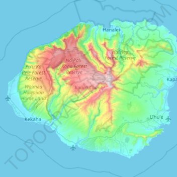
Name: Kauai topographic map, elevation, terrain.
Location: Kauai, Kauaʻi County, Hawaii, United States (21.86822 -159.78783 22.23271 -159.29232)
Average elevation: 709 ft
Minimum elevation: 0 ft
Maximum elevation: 5,144 ft
Kauaʻi County trails, hiking, mountain biking, running and outdoor activities
Other topographic maps
Click on a map to view its topography, its elevation and its terrain.