
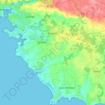
Trégunc topographic map
Interactive map
Click on the map to display elevation.
About this map
Name: Trégunc topographic map, elevation, terrain.
Average elevation: 82 ft
Minimum elevation: -13 ft
Maximum elevation: 318 ft
Other topographic maps
Click on a map to view its topography, its elevation and its terrain.
Lotissement Parc Ar Feunteun
France > Brittany > Finistère > Plouégat-Guérand
Average elevation: 256 ft
Moulin du Bois
France > Brittany > Finistère > Hôpital-Camfrout > L'Hôpital-Camfrout
Average elevation: 157 ft
Résidence du Bois Pleuven
France > Brittany > Finistère > Résidence du Bois Pleuven
Average elevation: 318 ft
Lae Locjhou
France > Brittany > Finistère > La Forêt-Fouesnant > Lae Locjhou
Average elevation: 249 ft