
Make a donation
Gear up for your next adventure:
As an Amazon Associate, this site earns from qualifying purchases at no extra cost to you.
Wilmington topographic map
Click on the map to display elevation.
Make a donation
Gear up for your next adventure:
As an Amazon Associate, this site earns from qualifying purchases at no extra cost to you.
Wilmington
Wilmington sits near the southeastern coast and has a low-lying, relatively flat topography with an average elevation around 36 feet above sea level. The terrain is characterized by coastal plains with minimal elevation changes, making the landscape generally flat as it gently slopes toward the Atlantic Ocean. This area is also influenced by proximity to the Cape Fear River and various tidal creeks, contributing to flood-prone lowlands, especially during heavy rains and tropical storms. The surrounding terrain includes sandy soils and marshy wetlands, which are typical of coastal environments in North Carolina.
Make a donation
Gear up for your next adventure:
As an Amazon Associate, this site earns from qualifying purchases at no extra cost to you.
About this map
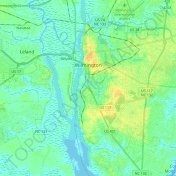
Name: Wilmington topographic map, elevation, terrain.
Average elevation: 23 ft
Minimum elevation: -7 ft
Maximum elevation: 75 ft
New Hanover County trails, hiking, mountain biking, running and outdoor activities
Make a donation
Gear up for your next adventure:
As an Amazon Associate, this site earns from qualifying purchases at no extra cost to you.
Other topographic maps
Click on a map to view its topography, its elevation and its terrain.
Ogden Park
United States > North Carolina > New Hanover County > Wilmington > Ogden
Average elevation: 43 ft
Parmele Isles
United States > North Carolina > New Hanover County > Wrightsville Beach
Average elevation: 3 ft
Long Leaf Acres
United States > North Carolina > New Hanover County > Wilmington
Average elevation: 36 ft
Make a donation
Gear up for your next adventure:
As an Amazon Associate, this site earns from qualifying purchases at no extra cost to you.
Wilmington Beach
United States > North Carolina > New Hanover County > Carolina Beach
Average elevation: 7 ft
Wilmington Beach
United States > North Carolina > New Hanover County > Carolina Beach
Average elevation: 7 ft
Make a donation
Gear up for your next adventure:
As an Amazon Associate, this site earns from qualifying purchases at no extra cost to you.
College Acres
United States > North Carolina > New Hanover County > Wilmington
Average elevation: 36 ft
Make a donation
Gear up for your next adventure:
As an Amazon Associate, this site earns from qualifying purchases at no extra cost to you.
Forest Hills
United States > North Carolina > New Hanover County > Wilmington
Average elevation: 36 ft
Bradley Creek Point
United States > North Carolina > New Hanover County > Wilmington
Average elevation: 10 ft
Make a donation
Gear up for your next adventure:
As an Amazon Associate, this site earns from qualifying purchases at no extra cost to you.
Wrightsville
United States > North Carolina > New Hanover County > Wilmington
Average elevation: 13 ft
Hanby Beach
United States > North Carolina > New Hanover County > Kure Beach > Hanby Beach
Average elevation: 3 ft
Make a donation
Gear up for your next adventure:
As an Amazon Associate, this site earns from qualifying purchases at no extra cost to you.