
Delta Junction topographic map
Interactive map
Click on the map to display elevation.
About this map
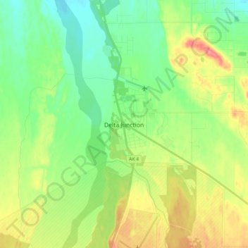
Name: Delta Junction topographic map, elevation, terrain.
Location: Delta Junction, Unorganized Borough, Alaska, United States (63.99735 -145.77216 64.07735 -145.69216)
Average elevation: 1,178 ft
Minimum elevation: 1,089 ft
Maximum elevation: 1,329 ft
Unorganized Borough trails, hiking, mountain biking, running and outdoor activities
Other topographic maps
Click on a map to view its topography, its elevation and its terrain.
Saint George Island
United States > Alaska > Unorganized Borough > St. George
Average elevation: 79 ft
Glacier Bay National Park and Preserve
United States > Alaska > Unorganized Borough > Gustavus
Average elevation: 72 ft
Chevak
United States > Alaska > Unorganized Borough
Chevak first appeared on the 1940 U.S. Census as an unincorporated native village. At the time it was located above the junction of the Keoklevik & Kashunuk Rivers at an altitude of 7 feet. 61°25′56″N 165°27′03″W / 61.43222°N 165.45083°W / 61.43222; -165.45083 (Old Chevak) In the 1940s,…
Average elevation: 26 ft
Nikolai
United States > Alaska > Unorganized Borough
Farewell Lake is a weather station roughly 38 miles south of Nikolai, at an elevation of 1060 ft (323.1 m). Farewell Lake has a subarctic climate (Köppen Dfc).
Average elevation: 433 ft
Paxson
United States > Alaska > Unorganized Borough
Paxson has a continental subarctic climate (Köppen Dfc), closely bordering on an alpine climate (Köppen ET) due to its high elevation and northerly latitude, with only one month above the 50 degree isotherm.
Average elevation: 3,330 ft
Akiak
United States > Alaska > Unorganized Borough
The airport has a gravel runway in good condition, measuring 3,196 feet (974 m) long by 75 feet (23 m) wide, at an elevation of 30 feet (9.1 m). The strip provides chartered or private air access year-round. Arctic Circle Air Service, Grant Aviation, and Hageland Aviation offer passenger flight service. Snow…
Average elevation: 16 ft