
Monroe County topographic map
Interactive map
Click on the map to display elevation.
Monroe County
Monroe County features a diverse topography characterized by rolling hills, flat plains, and numerous water bodies, including Lake Ontario to the north. The terrain rises gently from the shores of the lake, with elevations reaching approximately 800 feet (244 meters) in the southern regions, particularly near the escarpment of the Appalachian Mountains. This varying elevation contributes to a unique landscape, dotted with valleys, ravines, and wetlands, which are home to a rich array of ecosystems. The county's extensive park system showcases these natural features, providing opportunities for outdoor recreation amid scenic views. The area is also shaped by glacial activity, which has carved out distinct landforms and left behind rich soils ideal for agriculture.
About this map
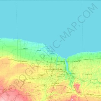
Name: Monroe County topographic map, elevation, terrain.
Location: Monroe County, New York, United States (42.93991 -78.00899 43.63475 -77.37128)
Average elevation: 400 ft
Minimum elevation: 236 ft
Maximum elevation: 1,112 ft
New York trails, hiking, mountain biking, running and outdoor activities
Other topographic maps
Click on a map to view its topography, its elevation and its terrain.
Central Park
United States > New York > New York County > New York
In June 1856, Fernando Wood appointed a "consulting board" of seven people, headed by author Washington Irving, to inspire public confidence in the proposed development. Wood hired military engineer Egbert Ludovicus Viele as the park's chief engineer, tasking him with a topographical survey of the site. The…
Average elevation: 85 ft
Niagara Escarpment
United States > New York > Niagara County > City of Lockport
Average elevation: 489 ft
South Setauket
United States > New York > Suffolk County > Town of Brookhaven
Average elevation: 144 ft
Central Park
United States > New York > New York County > New York
In June 1856, Fernando Wood appointed a "consulting board" of seven people, headed by author Washington Irving, to inspire public confidence in the proposed development. Wood hired military engineer Egbert Ludovicus Viele as the park's chief engineer, tasking him with a topographical survey of the site. The…
Average elevation: 85 ft
Holiday Valley
United States > New York > Cattaraugus County > Ellicottville
Average elevation: 1,788 ft
Platte Clove
United States > New York > Greene County > Town of Hunter > Platte Clove Bruderhof
Average elevation: 1,886 ft
Fort Edward Feeder Canal
United States > New York > Washington County > Village of Fort Edward
Average elevation: 187 ft
Coney Island
United States > New York > Saint Lawrence County > Town of Pierrepont
Average elevation: 571 ft
Buckhout Corners
United States > New York > Westchester County > Village of Briarcliff Manor
Average elevation: 367 ft
Mohegan Heights
United States > New York > Westchester County > City of Yonkers
Average elevation: 190 ft
Cooper Lake
United States > New York > Ulster County > Town of Woodstock > Lake Hill
Average elevation: 1,204 ft
Kaaterskill High Peak
United States > New York > Greene County > Town of Hunter
Average elevation: 2,789 ft
Harbor Hills Park
United States > New York > Nassau County > Village of Great Neck Estates
Average elevation: 33 ft
Woodcrest Bruderhof
United States > New York > Ulster County > Town of Esopus
Average elevation: 276 ft
Cowdens Corner
United States > New York > Chautauqua County > Town of Arkwright
Average elevation: 1,276 ft
Constantia Center
United States > New York > Oswego County > Town of Constantia
Average elevation: 554 ft
Dunham Hollow
United States > New York > Rensselaer County > Town of Nassau
Average elevation: 1,217 ft
South New Berlin
United States > New York > Chenango County > Town of New Berlin
Average elevation: 1,247 ft
Woodcock Mountain
United States > New York > Saratoga County > Town of Hadley
Average elevation: 889 ft
Ellenburg Mountain
United States > New York > Clinton County > Town of Ellenburg
Average elevation: 2,238 ft
Niagara Escarpment
United States > New York > Niagara County > City of Lockport
Average elevation: 489 ft
Lake Katonah
United States > New York > Westchester County > Town of Lewisboro
Average elevation: 417 ft
Mount Marcy
United States > New York > Essex County > Town of Keene
Mount Marcy is the highest point in the Adirondack Mountains and the U.S. state of New York, with an elevation of 5,343.1 feet (1,628.6 m). It is located in the town of Keene in Essex County. The mountain is in the heart of the High Peaks Wilderness Area in Adirondack Park. Like the surrounding Adirondack…
Average elevation: 4,229 ft
West Coxsackie
United States > New York > Greene County > Village of Coxsackie
Average elevation: 108 ft
Ontario Pond
United States > New York > Niagara County > City of North Tonawanda
Average elevation: 581 ft
West Genesee Terrace
United States > New York > Onondaga County > Fairmount > Town of Camillus
Average elevation: 548 ft