
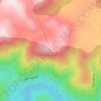
Mount Arrowsmith topographic map
Interactive map
Click on the map to display elevation.
About this map
Name: Mount Arrowsmith topographic map, elevation, terrain.
Location: Mount Arrowsmith, Tasmania, Australia (-42.21053 146.07518 -42.21043 146.07528)
Average elevation: 2,497 ft
Minimum elevation: 1,506 ft
Maximum elevation: 3,222 ft
Other topographic maps
Click on a map to view its topography, its elevation and its terrain.
Launceston
Launceston, City of Launceston, Tasmania, Australia
Average elevation: 636 ft
Queenstown
Queenstown, West Coast, Tasmania, 7467, Australia
Average elevation: 1,083 ft
Campbell Town
Australia > Tasmania > Campbell Town
Campbell Town, Northern Midlands, Tasmania, 7210, Australia
Average elevation: 1,132 ft
Clarence Point
Australia > Tasmania > Clarence Point
Clarence Point, West Tamar, Tasmania, Australia
Average elevation: 43 ft
Legana
Australia > Tasmania > Launceston > Legana
Legana, Launceston, West Tamar, Tasmania, Australia
Average elevation: 269 ft
Mount Nelson
Mount Nelson, Hobart, City of Hobart, Tasmania, Australia
Average elevation: 650 ft