
Tom Price topographic map
Interactive map
Click on the map to display elevation.
Tom Price
Tom Price is the closest town to Karijini National Park and is serviced by the nearby Paraburdoo Airport. Due to its elevation (747 m (2,451 ft)), temperatures are lowered and rainfall is intensified, resulting in the town possessing a subtropical semi-arid climate (Köppen: BSh). Summers are very hot with highly variable rainfall, while winters are mild and dry. Average maxima vary from 38.2 °C (100.8 °F) in January to 23.0 °C (73.4 °F) in July, while average minima fluctuate between 23.0 °C (73.4 °F) in January and 7.2 °C (45.0 °F) in July. Annual precipitation is rather low (averaging 404.8 mm (15.94 in)), and is spread across 36.8 precipitation days (over 1.0 mm (0.039 in)). Extreme temperatures have ranged from 45.0 °C (113.0 °F) on 27 December to −1.0 °C (30.2 °F) on 14 July 2002.
About this map
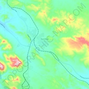
Name: Tom Price topographic map, elevation, terrain.
Average elevation: 2,595 ft
Minimum elevation: 2,218 ft
Maximum elevation: 3,681 ft
Other topographic maps
Click on a map to view its topography, its elevation and its terrain.
Gibson Desert
The Gibson Desert is located between the saline Kumpupintil Lake and Lake Macdonald along the Tropic of Capricorn, south of the Great Sandy Desert, east of the Little Sandy Desert, and north of the Great Victoria Desert. The altitude rises to just above 500 metres (1,600 ft) in places. As noted by early…
Average elevation: 1,522 ft
Perth
Australia > Western Australia > City of Perth
Perth, the capital of Western Australia, is situated on the Swan Coastal Plain, a flat expanse of sandy soil nestled between the Indian Ocean to the west and the Darling Scarp to the east. The Darling Scarp, also known as the Darling Range, is a low escarpment that extends north–south, marking a distinct…
Average elevation: 85 ft