Geolocate

Falls of the Ohio State Park topographic map

Interactive map

Click on the map to display elevation.

About this map

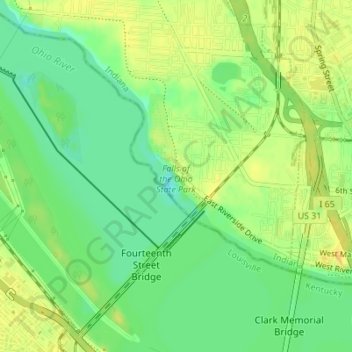
Name: Falls of the Ohio State Park topographic map, elevation, terrain.

Location: Falls of the Ohio State Park, Louisville, Jefferson County, Kentucky, United States (38.26893 -85.76619 38.28160 -85.75254)

Average elevation: 443 ft

Minimum elevation: 394 ft

Maximum elevation: 482 ft

Other topographic maps

Click on a map to view its topography, its elevation and its terrain.

Shawneeland

United States > Kentucky > Jefferson County > Louisville

Shawneeland, Louisville, Jefferson County, Kentucky, 40211, United States

Average elevation: 453 ft

Waverly Hills

United States > Kentucky > Jefferson County > Louisville

Waverly Hills, Louisville, Jefferson County, Kentucky, 40258, United States

Average elevation: 509 ft

Cherokee Park

United States > Kentucky > Jefferson County > Louisville

Cherokee Park, Louisville, Jefferson County, Kentucky, United States

Average elevation: 522 ft

Parkland

United States > Kentucky > Jefferson County > Louisville

Parkland, Louisville, Jefferson County, Kentucky, 40211, United States

Average elevation: 456 ft

Saint Matthews

United States > Kentucky > Jefferson County > Louisville

Saint Matthews, Louisville, Jefferson County, Kentucky, 40207, United States

Average elevation: 545 ft

Cherokee Garden

United States > Kentucky > Jefferson County > Louisville

Cherokee Garden, Louisville, Jefferson County, Kentucky, 40041, United States

Average elevation: 538 ft

Newburg

United States > Kentucky > Jefferson County > Louisville

Newburg, Louisville, Jefferson County, Kentucky, 40225, United States

Average elevation: 512 ft

Louisville-Jefferson County (Balance)

United States > Kentucky > Jefferson County > Louisville

Louisville-Jefferson County (Balance), Louisville, Jefferson County, Kentucky, 40231, United States

Average elevation: 515 ft

South Park

United States > Kentucky > Jefferson County > Louisville

South Park, Louisville, Jefferson County, Kentucky, 40118, United States

Average elevation: 489 ft

Mirror Lakes

United States > Kentucky > Jefferson County > Louisville > Hopewell

Mirror Lakes, Hopewell, Louisville, Jefferson County, Kentucky, United States

Average elevation: 650 ft

Fern Creek

United States > Kentucky > Jefferson County > Louisville

Fern Creek, Louisville, Jefferson County, Kentucky, 40291, United States

Average elevation: 692 ft

Bethany

United States > Kentucky > Jefferson County > Louisville

Bethany, Louisville, Jefferson County, Kentucky, 40272, United States

Average elevation: 463 ft

Fairdale

United States > Kentucky > Jefferson County > Louisville

Fairdale, Louisville, Jefferson County, Kentucky, 40118, United States

Average elevation: 518 ft