
Îlot Mbouzi topographic map
Interactive map
Click on the map to display elevation.
About this map
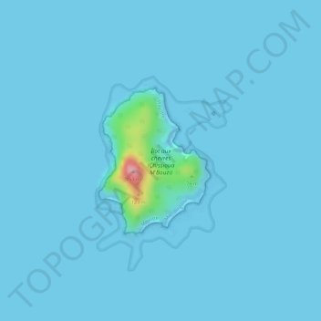
Name: Îlot Mbouzi topographic map, elevation, terrain.
Location: Îlot Mbouzi, Mamoudzou, Mayotte, 97600, France (-12.81686 45.23064 -12.80459 45.24027)
Average elevation: 16 ft
Minimum elevation: 0 ft
Maximum elevation: 449 ft
Other topographic maps
Click on a map to view its topography, its elevation and its terrain.
Tsoundzou 1
Tsoundzou 1, Mamoudzou, Mayotte, 97605, France
Average elevation: 171 ft
Parc de la Pointe Mahabou
Parc de la Pointe Mahabou, Doujani, Mamoudzou, Mayotte, 97600, France
Average elevation: 20 ft