
Make a donation
Gear up for your next adventure:
As an Amazon Associate, this site earns from qualifying purchases at no extra cost to you.
Rietvlei Nature Reserve topographic map
Click on the map to display elevation.
Make a donation
Gear up for your next adventure:
As an Amazon Associate, this site earns from qualifying purchases at no extra cost to you.
Rietvlei Nature Reserve
Rietvlei Nature Reserve, located in southern Pretoria, is about 4,000 hectares (40 km2) in size, and includes the entirety of the Rietvlei Dam which impounds the Rietvlei River, in Gauteng, South Africa. The reserve is wedged between the R21 highway (OR Tambo Airport highway) on the western side and the R50 (Delmas-Bapsfontein) road on the north-east. The mean elevation above sea level is approximately 1,525 meters, with the highest point at 1,542 m and the lowest at 1,473 m, the dam’s outflow in Sesmylspruit. The reserve covers a surface area of approximately 4,003 ha or 40 km2, of which the dam constitutes some 20ha. A network of roads criss-cross the entire area, which facilitates access to visitors and management.
Make a donation
Gear up for your next adventure:
As an Amazon Associate, this site earns from qualifying purchases at no extra cost to you.
About this map
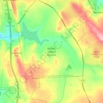
Name: Rietvlei Nature Reserve topographic map, elevation, terrain.
Average elevation: 4,984 ft
Minimum elevation: 4,741 ft
Maximum elevation: 5,249 ft
Make a donation
Gear up for your next adventure:
As an Amazon Associate, this site earns from qualifying purchases at no extra cost to you.
Other topographic maps
Click on a map to view its topography, its elevation and its terrain.
Roodeplaat Dam
South Africa > Gauteng > City of Tshwane Metropolitan Municipality
Average elevation: 4,068 ft
Kruin Park
South Africa > Gauteng > City of Tshwane Metropolitan Municipality > Pretoria
Average elevation: 4,528 ft
Trim Park
South Africa > Gauteng > City of Tshwane Metropolitan Municipality > Pretoria
Average elevation: 4,167 ft
Apies
South Africa > Gauteng > City of Tshwane Metropolitan Municipality > Pretoria
Average elevation: 4,101 ft
Make a donation
Gear up for your next adventure:
As an Amazon Associate, this site earns from qualifying purchases at no extra cost to you.
Faerie Glen
South Africa > Gauteng > City of Tshwane Metropolitan Municipality
Average elevation: 4,603 ft
Freedom Park
South Africa > Gauteng > City of Tshwane Metropolitan Municipality > Pretoria
Average elevation: 4,560 ft
Faerie Glen Nature Reserve
South Africa > Gauteng > City of Tshwane Metropolitan Municipality > Pretoria
Average elevation: 4,544 ft
Ezemvelo Nature Reserve
South Africa > Gauteng > City of Tshwane Metropolitan Municipality
Average elevation: 4,462 ft
Make a donation
Gear up for your next adventure:
As an Amazon Associate, this site earns from qualifying purchases at no extra cost to you.
Prince's Park
South Africa > Gauteng > City of Tshwane Metropolitan Municipality > Pretoria
Average elevation: 4,347 ft