
Make a donation
Gear up for your next adventure:
As an Amazon Associate, this site earns from qualifying purchases at no extra cost to you.
Roodeplaat Dam topographic map
Click on the map to display elevation.
Make a donation
Gear up for your next adventure:
As an Amazon Associate, this site earns from qualifying purchases at no extra cost to you.
About this map
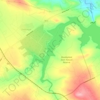
Name: Roodeplaat Dam topographic map, elevation, terrain.
Average elevation: 4,068 ft
Minimum elevation: 3,816 ft
Maximum elevation: 4,308 ft
Make a donation
Gear up for your next adventure:
As an Amazon Associate, this site earns from qualifying purchases at no extra cost to you.
Other topographic maps
Click on a map to view its topography, its elevation and its terrain.
Rietvlei Nature Reserve
South Africa > Gauteng > City of Tshwane Metropolitan Municipality
Rietvlei Nature Reserve, located in southern Pretoria, is about 4,000 hectares (40 km2) in size, and includes the entirety of the Rietvlei Dam which impounds the Rietvlei River, in Gauteng, South Africa. The reserve is wedged between the R21 highway (OR Tambo Airport highway) on the western side and the R50…
Average elevation: 4,984 ft
Dinokeng Game Reserve
South Africa > Gauteng > City of Tshwane Metropolitan Municipality > Mongena Game Lodge
Average elevation: 3,671 ft
Apies River
South Africa > Gauteng > City of Tshwane Metropolitan Municipality
Average elevation: 4,016 ft
Tshwane Ward 83
South Africa > Gauteng > City of Tshwane Metropolitan Municipality
Average elevation: 4,915 ft
Make a donation
Gear up for your next adventure:
As an Amazon Associate, this site earns from qualifying purchases at no extra cost to you.
Tshwane Ward 47
South Africa > Gauteng > City of Tshwane Metropolitan Municipality
Average elevation: 4,997 ft
Tshwane Ward 48
South Africa > Gauteng > City of Tshwane Metropolitan Municipality
Average elevation: 4,472 ft
Struben Dam
South Africa > Gauteng > City of Tshwane Metropolitan Municipality > Pretoria
Average elevation: 4,544 ft