
Carlton topographic map
Interactive map
Click on the map to display elevation.
About this map
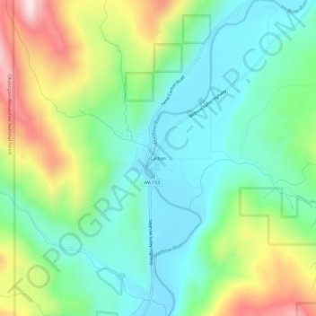
Name: Carlton topographic map, elevation, terrain.
Location: Carlton, Okanogan County, Washington, 98814, United States (48.22820 -120.13619 48.26820 -120.09619)
Average elevation: 1,939 ft
Minimum elevation: 1,368 ft
Maximum elevation: 3,150 ft
Okanogan County trails, hiking, mountain biking, running and outdoor activities
Other topographic maps
Click on a map to view its topography, its elevation and its terrain.
Tonasket
United States > Washington > Okanogan County
Tonasket is located along the Okanogan River at an altitude of 1,311 ft (400 m).
Average elevation: 1,122 ft
Omak
United States > Washington > Okanogan County
Elevations around the area range from 780 feet (240 m) above sea level at the mouth of the Okanogan River to 6,774 feet (2,065 m) above sea level at the Moses Mountain. The average elevation is 843 feet (257 m) above sea level according to the United States Geological Survey (USGS). The Moses Mountain, with a…
Average elevation: 1,194 ft
Winthrop
United States > Washington > Okanogan County
Winthrop lies at the confluence of the Methow and Chewuch rivers in the Methow Valley. The town is in the eastern foothills of the Cascade Mountains at an elevation of 1,760 feet (540 m). The Okanogan–Wenatchee National Forest and state-managed Methow Wildlife Area surround the Methow Valley.
Average elevation: 1,860 ft
Omak
United States > Washington > Okanogan County
Elevations around the area range from 780 feet (240 m) above sea level at the mouth of the Okanogan River to 6,774 feet (2,065 m) above sea level at the Moses Mountain. The average elevation is 843 feet (257 m) above sea level according to the United States Geological Survey (USGS). The Moses Mountain, with a…
Average elevation: 1,194 ft
Tonasket
United States > Washington > Okanogan County
Tonasket is located at 48°42′20″N 119°26′19″W / 48.70556°N 119.43861°W / 48.70556; -119.43861 (48.705626, -119.438568). at an altitude of 1,311 ft (400 m).
Average elevation: 1,122 ft
Tonasket
United States > Washington > Okanogan County
Tonasket is located along the Okanogan River at an altitude of 1,311 ft (400 m).
Average elevation: 1,122 ft