
Montevideo topographic map
Interactive map
Click on the map to display elevation.
Montevideo
The surrounding topography is dominated by farmland and prairies, as well as river valleys with many scenic overlooks and small bluffs.
About this map
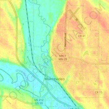
Name: Montevideo topographic map, elevation, terrain.
Location: Montevideo, Chippewa County, Minnesota, United States (44.92942 -95.74208 44.97665 -95.67996)
Average elevation: 991 ft
Minimum elevation: 919 ft
Maximum elevation: 1,060 ft
Chippewa County trails, hiking, mountain biking, running and outdoor activities
Other topographic maps
Click on a map to view its topography, its elevation and its terrain.