Geolocate

Asbury topographic map

Click on the map to display elevation.

About this map

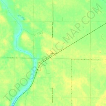
Name: Asbury topographic map, elevation, terrain.

Location: Asbury, Chippewa County, Minnesota, United States (44.85885 -95.55391 44.89885 -95.51391)

Average elevation: 1,037 ft

Minimum elevation: 988 ft

Maximum elevation: 1,060 ft

Chippewa County trails, hiking, mountain biking, running and outdoor activities

Other topographic maps

Click on a map to view its topography, its elevation and its terrain.

Milan

United States > Minnesota > Chippewa County

Average elevation: 1,020 ft

Watson

United States > Minnesota > Chippewa County

Average elevation: 1,001 ft

Maynard

United States > Minnesota > Chippewa County

Average elevation: 1,033 ft

Clara City

United States > Minnesota > Chippewa County

Average elevation: 1,060 ft

Gear up for your next adventure:

🔪Outdoor Multitools - Essential survival tools for gear repair and field use
🎒Trail Energy Bars - High‑calorie bars for hiking energy
📶Vehicle Signal Boosters - Improve reception in rural areas while driving to trailheads
🔌Solar Panel Charger - Charge gear sustainably outdoors
🗺️NatGeo Topo Maps - High-quality waterproof printed topographic maps of US Parks

As an Amazon Associate, this site earns from qualifying purchases at no extra cost to you.