
Make a donation
Gear up for your next adventure:
As an Amazon Associate, this site earns from qualifying purchases at no extra cost to you.
Pittston topographic map
Click on the map to display elevation.
Make a donation
Gear up for your next adventure:
As an Amazon Associate, this site earns from qualifying purchases at no extra cost to you.
Pittston
The city can be divided into three sections: the Oregon Section (located in southern Pittston), the Downtown (or City Center), and the Junction (or Upper Pittston). The Oregon Section is a neighborhood located on high ground overlooking the Susquehanna River (in the southern half of the city). The Downtown is located to the north (in the central part of Pittston). U.S. Route 11 passes through this part of the city. Two bridges cross over the Susquehanna and connect the Downtown with the Borough of West Pittston (on the opposite bank). The Downtown is where most of the city's businesses and high-rises exist. The elevation climbs as you move inland (eastward) away from the Susquehanna. The northernmost section of the city is known as the Junction. It is named after the railroad junction (or the Duryea Yard) which runs through its borders. It consists mostly of suburbs built upon several steep hills which overlook both the Susquehanna and Lackawanna Rivers. The Lackawanna River makes up Pittston's northern border.
Make a donation
Gear up for your next adventure:
As an Amazon Associate, this site earns from qualifying purchases at no extra cost to you.
About this map
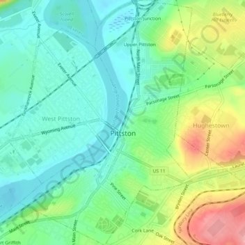
Name: Pittston topographic map, elevation, terrain.
Location: Pittston, Luzerne County, Pennsylvania, United States (41.31054 -75.80928 41.34418 -75.77665)
Average elevation: 646 ft
Minimum elevation: 522 ft
Maximum elevation: 906 ft
Luzerne County trails, hiking, mountain biking, running and outdoor activities
Make a donation
Gear up for your next adventure:
As an Amazon Associate, this site earns from qualifying purchases at no extra cost to you.
Other topographic maps
Click on a map to view its topography, its elevation and its terrain.
Make a donation
Gear up for your next adventure:
As an Amazon Associate, this site earns from qualifying purchases at no extra cost to you.
Cambra
United States > Pennsylvania > Luzerne County > Huntington Township
Average elevation: 1,020 ft
Make a donation
Gear up for your next adventure:
As an Amazon Associate, this site earns from qualifying purchases at no extra cost to you.
Glen Summit
United States > Pennsylvania > Luzerne County > Fairview Township
Average elevation: 1,768 ft
Roaring Brook
United States > Pennsylvania > Luzerne County > Hunlock Township
Average elevation: 1,106 ft
Shavertown
United States > Pennsylvania > Luzerne County > Kingston Township
Average elevation: 1,158 ft
Make a donation
Gear up for your next adventure:
As an Amazon Associate, this site earns from qualifying purchases at no extra cost to you.
Springtown
United States > Pennsylvania > Luzerne County > Dorrance Township
Average elevation: 1,299 ft
Wapwallopen
United States > Pennsylvania > Luzerne County > Conyngham Township
Average elevation: 732 ft
Town Hill
United States > Pennsylvania > Luzerne County > Huntington Township
Average elevation: 922 ft
Make a donation
Gear up for your next adventure:
As an Amazon Associate, this site earns from qualifying purchases at no extra cost to you.
Huntington Mills
United States > Pennsylvania > Luzerne County > Huntington Township
Average elevation: 948 ft
Hillside
United States > Pennsylvania > Luzerne County > Kingston Township
Average elevation: 1,122 ft
Sweet Valley
United States > Pennsylvania > Luzerne County > Ross Township
Average elevation: 1,280 ft
Make a donation
Gear up for your next adventure:
As an Amazon Associate, this site earns from qualifying purchases at no extra cost to you.
Make a donation
Gear up for your next adventure:
As an Amazon Associate, this site earns from qualifying purchases at no extra cost to you.
Shavertown
United States > Pennsylvania > Luzerne County > Kingston Township
Average elevation: 1,158 ft
Liewellyn Corners
United States > Pennsylvania > Luzerne County > Bear Creek Township
Average elevation: 1,473 ft
Hunlock Creek
United States > Pennsylvania > Luzerne County > Hunlock Township > Hunlock
Average elevation: 906 ft
Make a donation
Gear up for your next adventure:
As an Amazon Associate, this site earns from qualifying purchases at no extra cost to you.
Wapwallopen
United States > Pennsylvania > Luzerne County > Conyngham Township
Average elevation: 732 ft
Fern Glen
United States > Pennsylvania > Luzerne County > Black Creek Township
Average elevation: 1,283 ft
Make a donation
Gear up for your next adventure:
As an Amazon Associate, this site earns from qualifying purchases at no extra cost to you.
Cambra
United States > Pennsylvania > Luzerne County > Huntington Township
Average elevation: 1,020 ft
South Pond Dam
United States > Pennsylvania > Luzerne County > Hanover Township
Average elevation: 669 ft
Ricketts Glen State Park
United States > Pennsylvania > Luzerne County > Fairmount Township
The state's original plans for the new park included building an inn, an 18-hole golf course and country club, and a winter sports complex for skiing, ice boating, and tobogganing, as well as a beach with bathing facilities, cabins, and a tent camping area. Only the last three were actually built, all south of…
Average elevation: 1,929 ft
Make a donation
Gear up for your next adventure:
As an Amazon Associate, this site earns from qualifying purchases at no extra cost to you.
Fern Glen
United States > Pennsylvania > Luzerne County > Black Creek Township
Average elevation: 1,283 ft
Red Rock
United States > Pennsylvania > Luzerne County > Fairmount Township
Average elevation: 1,437 ft
Make a donation
Gear up for your next adventure:
As an Amazon Associate, this site earns from qualifying purchases at no extra cost to you.